Jamaica entered a critical phase of storm preparedness on Sunday as Hurricane Melissa continued to strengthen over very warm Caribbean waters. The system began as a tropical storm several days ago and has already produced deadly flooding in Hispaniola. It now poses a direct threat to Jamaica with dangerous winds, torrents of rain and life threatening storm surge possible through early week. What happens in the next forty eight hours matters because the storm is moving slowly and the hazards will build over time, not all at once.
What the latest forecasts show
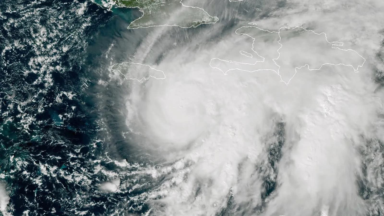
As of 06:00 UTC on Sunday 26 October, the United States National Hurricane Center reported that Melissa had rapidly intensified into a Category 3 hurricane with maximum sustained winds near 120 miles per hour. The center of the storm was about 125 miles south southeast of Kingston and the motion was toward the west southwest at around 5 miles per hour. Forecast guidance indicates a continued slow track that brings the core near or over Jamaica Monday night or Tuesday, followed by a turn that could take the system toward eastern Cuba by midweek. The risk profile is not only about wind. The storm carries an expansive rain shield that can produce long duration flooding over successive days.
Forecasters call for continued rapid intensification in the next day or so, with typical fluctuations after that. Category 4 strength is possible if the inner core remains intact over very high ocean heat content. While maximum winds may wobble during eyewall replacement cycles, the rainfall hazard is unequivocal. The official outlook highlights totals of fifteen to thirty inches in parts of Jamaica and southern Hispaniola with local maxima up to forty inches, especially along mountainous terrain where upslope flow squeezes out more moisture.
Warnings and what they mean
A hurricane warning is in effect for Jamaica. That signals that hurricane conditions are expected within thirty six hours and that preparations should be completed before tropical storm force winds make outdoor work dangerous. A hurricane watch is in effect for the southwestern peninsula of Haiti from the border with the Dominican Republic to Port au Prince and for the Cuban provinces of Granma, Santiago de Cuba, Guantanamo and Holguin. A tropical storm warning is also in effect for the same southwestern peninsula of Haiti, reflecting the broader field of hazardous winds and squalls away from the core.
For readers following search trends about tropical storm warning and whether those alerts still apply, the answer depends on geography and timing. Jamaica has escalated to a hurricane warning as Melissa intensified. Tropical storm warnings and watches remain relevant for surrounding coasts and islands that face strong winds outside the eyewall. The practical guidance is the same. Secure property, avoid coastal exposure, stay in touch with official bulletins, and be ready to move to higher ground if instructed by authorities.
Government preparations and public guidance
Jamaican officials have emphasized readiness over reassurance. Prime Minister Andrew Holness urged residents to prepare supplies and to consider voluntary evacuation from low lying and landslide prone areas ahead of the worst conditions. Authorities announced the closure of Norman Manley International Airport in Kingston and activated more than 650 shelters across the island, with warehouses pre stocked for rapid distribution of food and water. The goal is to keep people off flooded roads and out of rapidly rising gullies that become deadly during cloudbursts. The Meteorological Service of Jamaica has cautioned that apparent wobbles in the track do not meaningfully reduce risk. A small shift can move the zone of destructive winds and surge toward densely populated corridors while the mountainous interior funnels runoff into communities that flood quickly.
The hazards in detail
Freshwater flooding and landslides are the central concern. Repeated rain bands can deliver several inches of rain per hour. Rivers and streams that appear manageable at midday can become dangerous within minutes if an outer band stalls over a watershed. In addition to inland flooding, coastal surge is a growing threat as the storm strengthens. Official guidance calls for storm surge of nine to thirteen feet above ground level along the south coast of Jamaica near and to the east of where the center approaches, accompanied by large and destructive waves. Such surges do not require a direct landfall to be destructive because persistent winds pile water against the shoreline over many hours.
Wind damage is likely wherever the core or the powerful eastern semicircle passes. Concrete block structures typically fare better than wooden buildings, but roofs, signage, power lines and cell towers remain vulnerable at sustained hurricane force winds. Even tropical storm force gusts can topple trees in saturated soils. This is why the phrase tropical storm warning remains relevant across a wide area. Power outages can become widespread and prolonged when restoration crews must navigate landslides and inundated roads.
Context from a very active season
Hurricane Melissa is the thirteenth named storm of an Atlantic season that forecasters expected to be above average due to persistent ocean warmth. It follows systems that formed quickly or intensified rapidly, a behavior that has become more common in years with exceptionally warm sea surface temperatures. The pace of intensification matters for emergency managers because it compresses the window for final protective actions and strains logistics. Melissa’s slow movement through the central Caribbean also echoes historical cases where rainfall rather than wind caused the greatest loss of life.
What residents should do now
The most reliable guidance is simple. Monitor official updates from the National Hurricane Center and the Meteorological Service of Jamaica. If you live near the coast or in a flood prone valley, identify the nearest shelter and plan the safest route to reach it before conditions deteriorate. Charge devices and prepare for a multi day disruption in water and electricity. Avoid driving through flooded roads because the depth and speed of floodwaters are difficult to judge, especially at night. For readers tracking phrases like tropical storm Melissa hurricane Jamaica in search results, remember that labels will change as intensity evolves. The public safety actions do not. Follow local instructions first.
A measured outlook
If the forecast verifies, Jamaica faces a severe test from a powerful hurricane at the height of the wet season. The island has prepared shelters, prepositioned supplies and elevated public messaging. The outcome will depend on how long Melissa lingers and where the most intense rain bands set up. For now the prudent course is to treat the situation as a high impact and multi day event. It is the rare combination of slow motion and steady strengthening that makes this storm so dangerous.
Sources: National Hurricane Center public advisory and graphics. Associated Press. Reuters. Meteorological Service of Jamaica and Jamaica Information Service.
Note: All information in this article is based on verified public data and credible sources available at the time of writing.